
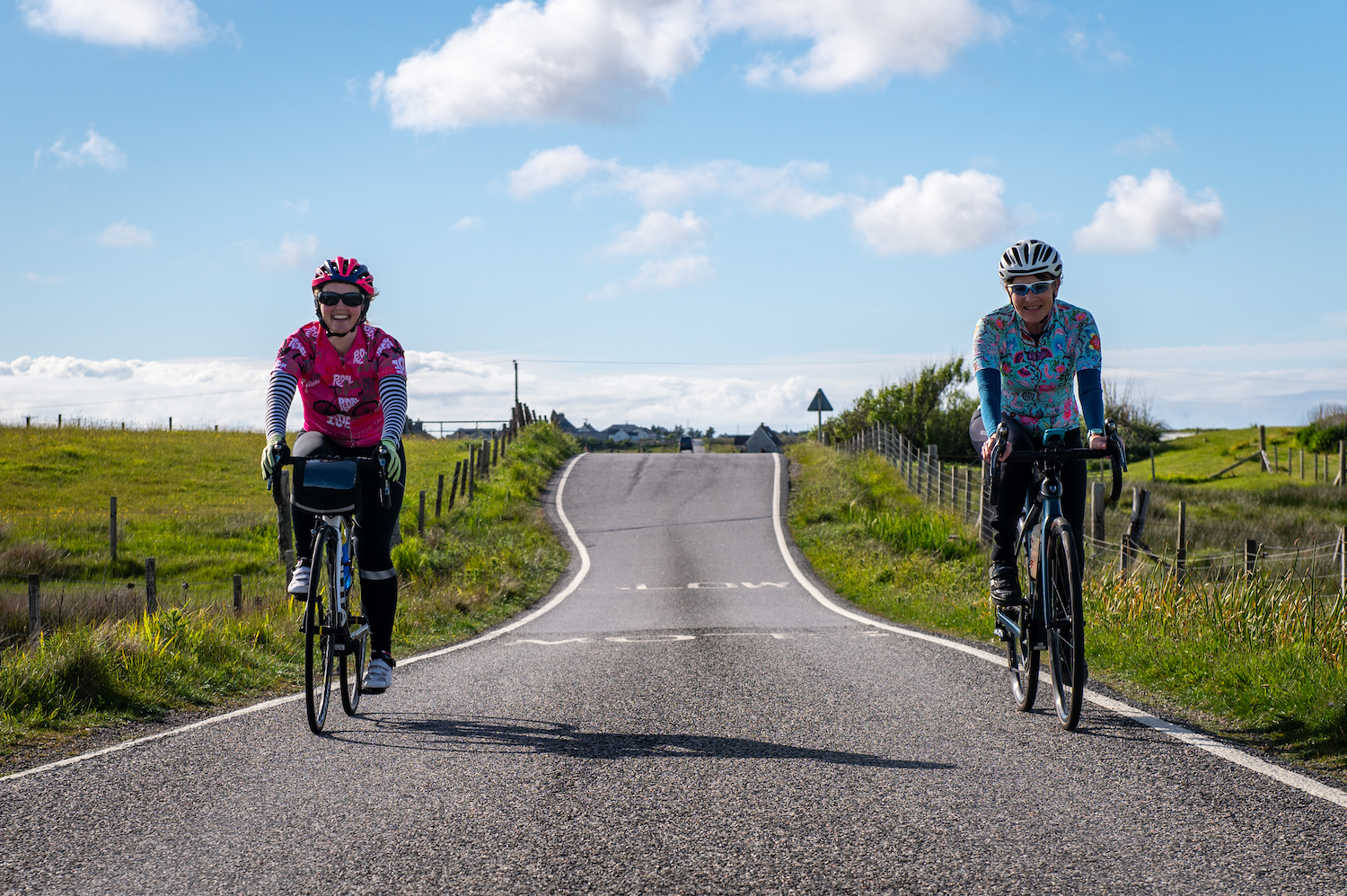
Mull of Galloway to John o’Groats
The ultimate long-distance road cycling in Scotland
South to north across Scotland by bike
New for 2026, and already attracting a lot of interest, this trip promises to be an incredible journey across the length and breadth of Scotland.
Never satisfied with taking the easy or direct route, our itinerary will take you to the west coast islands, through glens and over mountains as you journey from the southernmost to northernmost points in Scotland.
We can guarantee that there is not another cycling holiday like it in the UK.
Mull of Galloway to John o’Groats
Our fully supported cycling tour from the Mull of Galloway to John o’Groats winds north from Scotland’s southernmost tip to the the Atlantic.
Scotland, south to north
The Mull of Galloway to John o’Groats cycling holiday
Starting at Scotland’s southernmost tip at the lighthouse at Carrickcarlin Point on the Mull of Galloway, this route heads north for eight spectacular days of riding and ends at John o’Groats on the north coast of Scotland.
The journey takes you up the west coast to the Isle of Bute, across Loch Lomond (on a waterbus!) and follows the trails of the Jacobite outlaw, Rob Roy MacGregor. Venturing into the Trossachs and Highland Perthshire, it continues north, crossing the Moray, Cromarty and Dornoch Firths on the way.
On the final day, the road takes you to the true northerly point on the British mainland, the Dunnet Head Lighthouse, before you ride the last few miles to John o’Groats.

Prices include
Logistics
Pre-trip logistics and planning. Every detail of your trip taken care of for you.
Accommodation
All accommodation for the duration of the holiday.
Food
Half-board including breakfast, snacks and three-course evening meals.
Support
Expert guided support from our local guides and our unique customised vehicles.
Record
A dedicated trip experience app, packed with information, notes and detailed GPS files for each day of cycling.
Transport
Luggage transfers, ferry crossings,
end-of-trip transfers.
Reviews
What our guests say
Mull of Galloway to John o'Groats: travel day
Day 1: Arrive in Troon

OH, I DO LIKE TO BE BESIDE THE SEASIDE!
Just a few miles from Prestwick International Airport and 45 minutes from Glasgow Central Station, Troon is a popular coastal town which boasts stunning, sandy beaches with magnificent views. Due to its accessible transport links, it's the perfect place to begin your MoGJoG trip.
The start hotel is a ten-minute walk from Troon railway station and has a long-term car park. Your guide will meet you at the start hotel from 3 pm.
We highly recommend taking your bike out for a short spin to ensure that everything is in working order after travelling to Scotland.
There is a welcome briefing for the whole group at 7 pm, then everyone dines together at 7.30 pm.
Mull of Galloway to John o'Groats: riding day
Day 2: Mull of Galloway to Troon

QUIET LANES AND WIDE HORIZONS
We organise the 2.5 hour transfer to Stevenson Tower, the lighthouse at Scotland’s southernmost point on the Mull of Galloway. This is where your MoGJoG cycling adventure begins.
Pedalling north along coastal cliff edges on the Mull of Galloway peninsula, your first miles are remote and invigorating.
Beyond New Luce, your route threads through forested glens and peaceful villages before easing towards Ayrshire.
The final miles of the day skirt the coast through Alloway and along the esplanade towards Troon. Your day ends with fantastic views across the Firth of Clyde towards the Isle of Arran as you spin your wheels to the hotel.
Terrain and challenges:
Well-surfaced country roads; prevailing south-westerly or westerly winds in exposed areas; steady drags rather than sharp climbs.
On the road to discovery:
The Gallie Craig Coffee House on the Mull of Galloway has a turf roof to help it blend into the landscape. From its interior, you can see Northern Ireland and the Isle of Man.
Mull of Galloway to John o'Groats: riding day
Day 3: Troon to Rothesay on the Isle of Bute via Largs

COASTAL PATHS, WOODLAND TRAILS AND ISLAND-DOTTED SEAS
Leaving Troon along the shoreline, your day begins gently on traffic-free coastal paths.
The route weaves inland through woodland and riverside paths around Irvine and Kilwinning before returning to the coast. The scenery shifts between tranquil leafy green corridors and open seaside stretches.
Beyond Largs, you climb to an invigorating exposed section before flowing down to Wemyss Bay and the ferry terminal.
After a short ferry crossing to Rothesay, you have the option to ride one of three clockwise circuits around the southern part of the Isle of Bute. But only after having ascended the fourteen hairpin bends on Serpentine Road which trails up Canada Hill!
Your hotel for the night is in Rothesay.
Terrain and challenges:
Well-surfaced cycle paths and quiet roads; westerly winds on exposed sections; gently undulating.
On the road to discovery:
Although it's only 15 miles long by 4 miles wide, the Isle of Bute has both Highland and lowland areas. These lie to the north and south, respectively, of the Highland Boundary Fault which bisects the island.
Mull of Galloway to John o'Groats: riding day
Day 4: Rothesay to Tarbet

A LOTTA LOTTA LOCHS
Today you head up to north Bute for a very short ferry transfer across the Kyles of Bute to Colintraive on the mainland. Your day's cycling starts on quiet roads skirting sea lochs and freshwater lochs alike.
The National Cycle Route takes you through the UK's oldest forest park, Argyll Forest Park, past Loch Striven and Loch Tarsan before the landscape opens out along the shores of Holy Loch and Loch Eck.
Your final miles of the day trace the edge of Loch Fyne then Loch Long, where the scenery becomes more dramatic and unmistakably Highland. The last stretch is a long descent to the banks of Loch Lomond to the hotel in Tarbet.
Terrain and challenges:
Generally good surfaces; a gently rolling profile with some short punchy climbs.
On the road to discovery:
During World War II, Holy Loch was used as a British Royal Navy submarine base. From 1961 to 1992, it was used as a US Navy ballistic missile submarine base.
Mull of Galloway to John o'Groats: riding day
Day 5: Tarbet to Crieff

TRAVERSING THE TROSSACHS, THE GATEWAY TO THE HIGHLANDS
The day starts with a short but spectacular waterbus journey across Loch Lomond to Inversnaid. The route then follows the Great Trossachs Path for 13 miles / 20.9 km of traffic-free, lochside roads past Loch Arklet, Loch Katrine, and Loch Achray. This is countryside cycling at its best, with wooded slopes, shimmering water, and breathtaking Trossachs views.
Beyond Callander, the landscape opens out as you head east towards Doune where you join the old railway line on a well-compacted gravel track that takes you into Dunblane.
Continuing through Perthshire you arrive in Crieff, a historic market town famous for being a major cattle droving hub in the 1700s, and later a Victorian health resort.
Terrain and challenges:
Smooth tarmac; steady gradients; some traffic-free sections.
On the road to discovery:
The beauty of Loch Katrine inspired Sir Walter Scott to write his famous 19th century poem, The Lady of the Lake.
It has also enchanted poets Samuel Coleridge and William Wordsworth.
Mull of Galloway to John o'Groats: riding day
Day 6: Crieff to Kingussie

CLIMBING TOWARDS HISTORY IN THE HIGHLANDS
Today's journey begins gently, on peaceful back roads through rolling Perthshire countryside.
Beyond Aberfeldy, you join National Cycle Route 7 which leads you into increasingly open landscapes. After the River Tummel, you climb gradually through remote upland scenery as you approach the Cairngorms National Park and continue on General Wade’s historic Military Road.
From the highpoint, you descend comfortably through Dalwhinnie before riding past the Centre of Scotland stone and one of the most beautiful views in Scotland. (We encourage you to stop and savour it!)
You then roll north through dramatic Highland landscapes into Newtonmore and on to Kingussie.
Terrain and challenges:
Mostly smooth road surfaces; steady gradients initially, then sustained but manageable ascents; little traffic beyond Aberfeldy; westerly winds on higher, more exposed sections.
On the road to discovery:
It’s said that anyone who manages to fall asleep on top of the Centre of Scotland stone will become a seer, gaining the power of prophetic sight in their dreams.
Mull of Galloway to John o'Groats: riding day
Day 7: Kingussie to North Kessok via Inverness
A BRIDGE TO THE FAR NORTH
Your journey out of Kingussie on National Cycle Route 7 takes you along the fringes of the Cairngorms through spirit-lifting Caledonian pine forest and open farmland.
Beyond Boat of Garten and Carrbridge, the landscape becomes more exposed. The Old Military Road leads you steadily north across open moorland.
Approaching Inverness, you pass the Cumberland Stone and Culloden Battlefield, the site of one of the most harrowing battles in British history.
The Kessock Bridge over the Beauly Firth marks the transition into the far north. Look out for dolphins as you cross. The day finishes quietly at North Kessock, where your hotel overlooks the water and the city of Inverness.
Terrain and challenges:
Well-surfaced roads; steady gradients; light traffic.
On the road to discovery:
Built in the 18th century, the Old Military Road was part of a network designed to improve access and control during the Jacobite uprisings.
It connects key historical sites including the Culloden Battlefield, where the final Jacobite rising met its grisly end.
Mull of Galloway to John o'Groats: riding day
Day 8: North Kessock to Altnahara

FROM OIL RIGS TO ANGLING
Leaving North Kessock, your route threads through the Black Isle, a low-lying peninsula known for its fertile farmland and surprisingly mild microclimate. You roll gently along to the ferry terminal at Cromarty.
After a 10-minute ferry crossing to Nigg you turn inland to pedal through increasingly open landscapes with a steadily growing sense of remoteness.
Beyond the Kyle of Sutherland, the scenery becomes unmistakably northern. Your road follows long glens and wide waters and the countryside feels wild.
Today's ride ends at the Altnaharra Hotel which, fittingly, was once a lodge for 19th century sportsmen and women.
Terrain and challenges:
Quiet roads; smooth surfaces, steady gradients and a sustained climb towards the end of the day. Wind on open stretches.
On the road to discovery:
The Black Isle is not, in fact, an island but a peninsula. It is surrounded on three sides by the sea: the Cromarty Firth lies to the north, the Beauly Firth to the south, and the Moray Firth to the east.
Mull of Galloway to John o'Groats: riding day
Day 9: Altnahara to John o'Groats

WILD STRATHS AND A CELEBRATED SIGNPOST
Your final day begins quietly, following the north shore of Loch Naver through one of the most remote-feeling parts of the MoGJoG journey. The landscape is wide and open, with long sightlines, moorland hills, and a real sense of space.
Beyond Kinbrace, the route threads through empty straths and along northern rivers. When there is a northerly wind, this reinforces the sense that you are riding right at the edge of the map.
Beyond Thurso, you follow the route east and up to Dunnet Head Lighthouse, the true northerly point of the British mainland. Retracing your tyre tracks for just a couple of miles, you then rejoin the eastbound road and roll gently along the final stretch to the iconic John o’Groats signpost.
It's a simple yet unmistakable end to a fantastic eight days of riding across Scotland from south to north.
Terrain and challenges:
Quiet, well-surfaced roads; rolling terrain on gentle gradients; wind in exposed areas.
On the road to discovery:
John o'Groats is named after Jan de Groot, a 15th century Dutch entrepreneur who successfully operated a ferry service from the harbour to Orkney after King James IV acquired it from Norway.
Mull of Galloway to John o'Groats: travel day
Day 10: Transfer from John o'Groats

You will be safely transferred from the hotel to Glasgow or Troon where your Skinny Tyres road cycling holiday ends.
This 6.5-hour road journey takes you via Inverness, Pitlochry, Perth and Stirling. There is a scheduled half-hour comfort stop in Aviemore at the halfway point. You arrive in Glasgow / Troon at approximately 2.45 pm / 3.30 pm respectively.